Wildwood Bayou 2016

Wildwood Bayou 2016

Friday, May 6, 2011

Gettysburg NMP


    The last couple of days we’ve spent a lot of time in the car. We took a drive to Gettysburg, PA to tour the famous battlefield and cemetery.  For even the casual observer to take a tour would require a full day. The thing that I like about touring these places is that you get a sense of the size of the endeavors. Reading about it in a book, you can’t really appreciate the difficulties, on all levels, that the combatants withstood. Another, more personal reason for visiting this particular battlefield, lies with my past. Way back in time, when I was a student in Command and General Staff College for the Army, we extensively studied this battle. We read the book “Killer Angels” by Michael Shaara and had to write a paper on Leadership using one of the commanders at Gettysburg as our subject. (I chose Gen. James Longstreet, Gen. Lee’s second in command if you’re interested and got an “A” on the paper.) Now was an opportunity to walk the ground that I had only seen from maps and classroom discussions. If you are so inclined, read the Shaara novel or rent the movie “Gettysburg” (which was based on the novel and historical facts) to gain a more in-depth knowledge of the subject. 


    Looking into old town Gettysburg. Throughout the three day battle, scouts from both sides used this tower to observe and plan their strategies. 


    From this tree line, the infamous “Pickett’s Charge” began. Pickett and his men crossed this open space headed towards the barn about a mile distant on the horizon. With no cover and a couple of these fences to cross, Pickett’s men did not fare too well. 
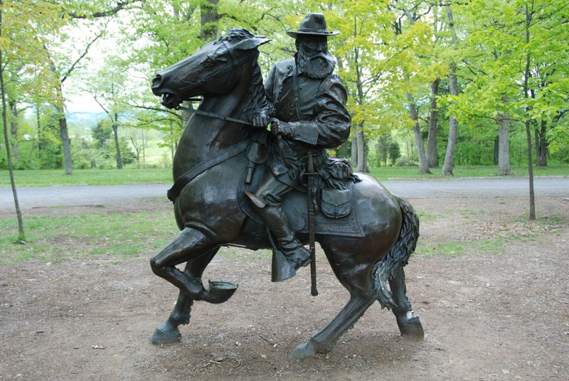

    A statue marking Gen. Longstreet’s field headquarters. 


    Looking across what was known as the Devil’s Den towards the hill called Little Round Top. This was beyond the far left edge of the Union line at the beginning of Day 2. Union leadership saw the weak spot and sent Col. Joshua Chamberlain and the 20th Maine to “hold the position at all costs”. This he did and the story is one of legend. After repeated Confederate charges, the 20th was down to only a couple rounds of ammunition per man. Col. Chamberlain ordered a bayonet charge and so skillfully executed the attack that he won the day and held the hill. For this action, he was awarded the Medal of Honor. 


    The view up Little Round Top from the Confederate’s viewpoint. The stone wall escarpment was built by the Union troopers overnight between Days 1 and 2 and still stands today. 


    Here is a marker that commemorates the deeds of the 20th Maine and marks the spot where they made their stand. 


    This is the Union view of the field where Pickett made his charge. Soldiers of his unit made it as far as the low stone wall in the center of the photo and into the grove of Oak trees at the left. Just to the right, out of the frame of this photo, is where Confederate Gen. Armistead was mortally wounded. This is the farthest the Confederates made it into the Union line. From here, they were repelled and ultimately defeated. 


    The stone wall that stopped the Confederate attack. Not much to look at, but imagine masses of artillery guns just to the left along with hundreds of Union infantrymen firing into the assault. 


    An artists rendition of Pickett’s Charge from the Union perspective. The stone wall is not visible, but runs along the middle of the scene. The small grove of Oak trees is visible on the far left center. 


      And the final stop, the National Cemetery. It was not far from this site that Abraham Lincoln delivered the immortal words of the Gettysburg Address on November 19, 1863 (some four and a half months after the battle). Following a 2+ hour speech by Edward Everett (a famous orator of the day), Lincoln took the stage and read the address in a little over 2 minutes! Take time to read it sometime, it still holds truths for today. 


    The casualties were originally buried in a semicircle around the center monument. There are 3,629 graves of Civil War dead in the 20 acre site. The deceased are organized by States and there are three sections for “Unknown”. 

Wednesday, May 4, 2011

300 Years in 2 Days


    Over the last couple of days, we have covered around 300 years of America’s history. Day one we went to visit Jamestown. This is the first permanent English settlement in the New World (before Plymouth and the Pilgrims). Here is where Capt. John Smith and the tale of Pocahontas took place (but not how Hollywood or Disney have portrayed it!). Here in May of 1607 a little over 100 brave souls (all men) landed ashore in hopes of establishing a presence for England in the New World. Spain and France had flitted around here for some time and England felt they were losing out on the riches to be had. They established a dirt walled fort that quickly proved to be insufficient to protect the new colonists from the existing inhabitants, the Powhatan nation. They proceeded to improve and build a much better fort and a replica of that is what is currently in place at the Jamestown Settlement Center. Just a few miles away from the original site, this area is an historically accurate recreation of the site and materials that were available to the colonists at the time. It is staffed by folks in period clothing who are available to answer questions or provide tidbits of information. There is also an extensive museum on site that traces events of the area from pre-Indian times through the early 1700’s. 
    The actual Jamestown site is an archeological dig that is located a few miles away and can be visited. We just didn’t have time to take in both in one day. 


    A rifle demonstration using a period matchlock rifle. Takes about 15-20 seconds to fire-reload-fire again.


    A recreation of the largest of the three ships that delivered the new colonists. This is the Susan Constant.


    This is the recreation of the Godspeed, the second of the three ships. Notice the guy going up the gangplank (for size reference). On this ship there were 50 men plus the crew that made the 5 month voyage! 


    Not a lot of room to put 50 people, is there?!?


    How to make a canoe using oyster shells. Iron tools weren’t readily available. Build a controlled fire then scrape the residue. Repeat as needed. You end up with a thin walled canoe with a thick, heavy bottom. Once in the water, it is nearly impossible to sink. 


    What one looks like that is finished.


    The walls of the fort. Notice that each plank is “nailed” in using 3 wooden pegs. The original wall was built in 19 days. The current re-creators, using modern equipment, were hard pressed to accomplish the same.  


    Powhatan village. Saplings are bent over, then lashed. Grass mats are woven and placed over the saplings. A fire is built and maintained for warmth, drying meat and  cooking. A small smoke hole in the top allows some smoke to escape. 


    Inside they are quite roomy. But it was said that they were very smoky when actually being lived in. 
    Our next stop jumps us up to the 1830’s. We visited the home of Thomas Jackson, better known as Confederate General “Stonewall” Jackson. Here in the small town of Lexington, just down the street from the Virginia Military Academy, Jackson had his home. It is actually two homes made into one. The original dwelling was brick. An addition was made some years later that is the stone, and which effectively doubled the size of the house. It was the only home that Jackson ever owned, and he lived here and taught at the Military Academy for some years before the Civil War.  Our tour of the home was led by Marta Kastner. Marta researched and wrote a book on Jackson entitled “Old Jack”. She was full of interesting information about the life and times of the General during his life in Lexington. 


    After the home, we went to the cemetery and visited the Jackson memorial. Here he was originally buried in a family plot, but was later moved to a prominent area in the center of the cemetery with an impressive memorial marker. 


    The original site. Jackson’s stone is on the upper row, second from the right. 


    This is where Jackson, his second wife, and an infant daughter are currently buried. Note the things that look like tennis balls. Seems that Jackson was a bit of a “health nut” before it was fashionable. He loved fresh fruit daily. During the Civil War, when apples were hard to come by, he was known to have chewed on lemons! In fact, one story says he relayed verbal orders to his commanders while having a slice of lemon in his mouth. To this day, there are always oranges or lemons around the monument. 
    Our next stop, coincidently in the same town, was Washington & Lee University. It was here that Robert E. Lee came following the signing of the surrender at Appomattox. He was offered, and took, the Presidentship of the University. It was here that he spent the remainder of his life. The college was a bit run down when he arrived and there were only 40 students. Lee took charge and through his leadership, the enrollment had blossomed to 400 within three years. One of the remarkable things Lee did was to eliminate all of the rules of the University and replace them with only one. It was an honor system that put the responsibility for fairness on the shoulder of the student. I was told that the honor system is still in place. Students can take exams in their dorm rooms. They are expected to abide by the code and not cheat. In October of 1870, Lee died of complications from a stroke. He, along with members of his family, are buried in the family crypt in the basement of the Chapel on campus. 


    The Lee Chapel and Museum. 


    This is a view of the side of the Chapel. The Lee Family crypt is through the double doors entryway at the bottom right of the building. The General’s horse, Traveller, is buried just outside of these doors. The horse was a mainstay of Lee’s existence during and after the war. In fact, the stable doors where Traveller stayed at the University President’s residence (now a garage) are left open at night so his spirit can come and go! Folks say that at times, you can hear hoofbeats at night around campus. 

Sunday, May 1, 2011

Monticello


    Today we spent most of the day visiting the home of our third President, Thomas Jefferson. Some things that I learned, or at least re-learned (a process that occurs more frequently as I get older!) are the many things that Jefferson did during his 33+ years of public service. He drafted and penned the Declaration of Independence. He served as delegate to the Virginia General Assembly and to Congress. He was Governor of Virginia, minister to France, Secretary of State, vice president, and two term President (from 1801 to 1809). Quite a resume! During his presidency, we doubled the size of our country via the Louisiana Purchase from France and he sponsored the Lewis and Clark expedition which opened our eyes to the vast riches of the west. 
    For forty years, he worked and re-worked on his beloved Monticello. Building and tearing down, then rebuilding. It always seemed to be in a state of construction. Jefferson loved science, architecture, and farming. He was always trying out new things or ways to do things. He tried to grow many different crops on his acreage; some worked, some didn’t. But he wasn’t discouraged with failure. He saw in failure a learning opportunity. At least now he knew what wouldn’t work! 
    Monticello has been restored to its 1812 appearance. Jefferson was a notorious (some would say compulsive) notetaker. He recorded the temperature, sky  conditions, and barometric pressure daily. He wrote down what he had told folks to do, how he spent his money, and he wrote volumes of letters. As a result of that documentation, the folks at Monticello have been able to restore the estate and its gardens down to using the exact plants in their exact locations. 
    The home itself is quite amazing. The intro picture is the front of the home. Remember the wind vane atop the roof over the entry way. I’ll get to it in a second. This is the second version of Monticello. Remember, Jefferson was working on this place for 40 years. During his ambassadorship in France, he was able to observe European architecture and gardening techniques and he brought back many of these and incorporated them into the house. 


    OK back to the weather vane. It’s all well and good if you are outside the house and look up to see the wind direction. What if you are in the entryway and want to know? Well, instead of going into the yard and looking up, you can just look up on the ceiling of the entryway. 


    There, attached to the vane, is a compass showing the current direction of the wind. Neat idea!
    Now here is the back of the house. Does it look a little bit familiar?


    Does this help jog your memory?


    Now the house itself is quite interesting, but photos were not allowed to be taken indoors, so you’ll just have to see it for yourself. There were some interesting engineering within the home. For instance, in the Tea room (which is on the North side), Jefferson used two panes of glass separated by about a foot of airspace in order to reduce the effect of the cold. Unheard of in his time. Hidden beneath the home was a tunnel which housed storage rooms (for beer and wine), stables, laundry facilities, a smokehouse, kitchen, and quarters for some of the house servants. There was also a huge circular storage bin 16 feet deep that was used for storage of ice. In January and February, they would cut ice from the nearby river and pack it into the ice house. They would pack snow around the ice and straw over the whole mess. This would usually last throughout the summer and was used to help refrigerate meat and cool wine.  The kitchen would prepare food and then it could be taken to a warming area beneath the dining room, where it could then be delivered to the waiting family. 


    Kitchen. Notice the individual cooking stations on the left. Each of them could hold a small charcoal fire and could cook a variety of dishes. The big fireplace could be used to roast large quantities of meat, and a small baking oven is off to the right of the big fireplace. 


    Looking down the hallway toward the kitchen in the far end. The main house is directly overhead and the South Pavilion walkway lies above the tunnel. 


    Wine and beer were stored in the cellar. These areas were under lock and key with only a few people having access to the area. 


    Behind the slave quarters, Jefferson kept an experimental garden where he tried growing a wide variety of vegetables and herbs. These are recreated based upon the original documented layouts. 


    A quarter-mile down from the gardens lies the Jefferson family cemetery. Under this obelisk lies Jefferson, his wife, two of his daughters, and a son-in-law. 


    One of the gates into the cemetery, showing the TJ initials. The base of the obelisk covering the Jefferson gravesite is barely in the picture on the right. 
    It is a very interesting piece of American history and we enjoyed it immensely. 
    We returned to our campsite, which is one of the most attractive ones that we have stayed at. The place is laid out like Disney. They have tried to hide power lines and the lights on the campsites are carefully incorporated into the decor. They have a huge swimming pool, a very nice camp store, two restaurants, a large lake with boat rentals, and a riding stable with surrounding trails. The afternoon of our arrival, we looked up at the sound of a thundering herd of some 35 horses galloping into the pasture at the front of our RV site.  After they settled and started to graze, this is what we got to see out our front window!


Tuesday, April 26, 2011

Parkways & National Parks


    Over the last couple of days, we have driven along many miles of the Blue Ridge Parkway. This scenic highway extends a total of 469 miles along the crests of the southern Appalachians and links two eastern National Parks: Shenandoah and Great Smoky Mountains. We didn’t drive the full length, but we did cover a lot of ground. The Great Smoky Mountain National Park was closest, so we toured through it. 


    The Blue Ridge Parkway winds across tree lined valleys and long mountain ridges. Once and a while, even through the mountain!


    The scenery is spectacular and photos can’t come close to the grandeur of the drive. 


    There are several turnouts and parking spots along the road, so many folks bring along a picnic lunch and nourish both the stomach and the soul. 


    From the picture above, you can see why they’re called the Smoky Mountains. It seems that the forest plants “exhale” water vapor that collects and forms a smoky haze throughout the mountains. 


    At the Oconaluftee Visitor Center, they have a Mountain Farm museum. Here actual buildings that were part of early 20th century farms are set up and, it appears, are occupied during the summer (no one was there when we visited but it looked like folks worked the farm). There was no indoor plumbing in the mountains then, just the outhouse. Which is there, but more modern facilities are at the Visitors Center.


    They had a corn crib there with a machine that removed the kernels from the cob. Now, not to say I’m old or anything, but I used to spend summers on my grandparents’ farm in Missouri. They didn’t have indoor plumbing until the early 1970’s. As a youngster, I remember being given baths in the washtub. I remember the outhouse and I also remember the corn crib. They had a machine similar to what we say here. It was my job to take the ears of corn, put them in the hopper, then turn the big crank that fed the ears into one end of the machine, and spit the cob out the other (and the shelled corn into a bucket underneath). Wow, this place brought back memories I had forgotten about!


    We continued our drive into the park and headed towards a place called Clingmans Dome. This is at the edge of a mountain that runs along the North Carolina and Tennessee border. It is reached by following a very steep, paved .5 mile walk. At the end of the trail, there is a concrete viewing platform that, on a good day, you can see 7 states! Or so I’m told. Unfortunately, a storm blew in, the temperature dropped, and the clouds obscured any view we might have. 


    Up the trail and the fog is getting thicker. 


    Made it to the lookout.


    You can see for miles and miles... NOT.
    Running through the Park is part of the Appalachian Trail. This foot trail runs from Maine to Georgia. It is the longest continually marked footpath in the world at 2,180 miles. I hiked some of it, just to say I did.


    All in all, this is a very impressive part of the world. Everyone should take the time to come and experience it.